How Difficult is it to Climb Umbwe Route to Mount Kilimanjaro? : Hello, hikers and tourists! We’ll talk about the quickest and most direct route to the summit of Kilimanjaro- Uhuru Peak. For novice trekkers and seasonal climbers, the Umbwe Route presents a very high degree of difficulty. Starting from the south of Kilimanjaro and passing through a tropical rain forest, it is the steepest path. The Umbwe route offers a direct but difficult route and hence low success rate of reaching the summit. This path could put you at a significant risk of getting altitude sickness and nausea if you don’t properly acclimate. The path is designed by nature for those who are in good bodily and mental health. Strong hikers and experienced trekkers are the ones advised to use this route.
How difficult is the Umbwe route?
The Umbwe path is the quickest of all the Kilimanjaro routes, although climbing to this greater elevation is never simple. Most hikers experience breathlessness even at elevations lower than 4000 meters. The most difficult and least utilized trekking route is the Umbwe trail. The Umbwe route is especially challenging because of the 3976m-long, sharpest path leading to the Barranco camp.
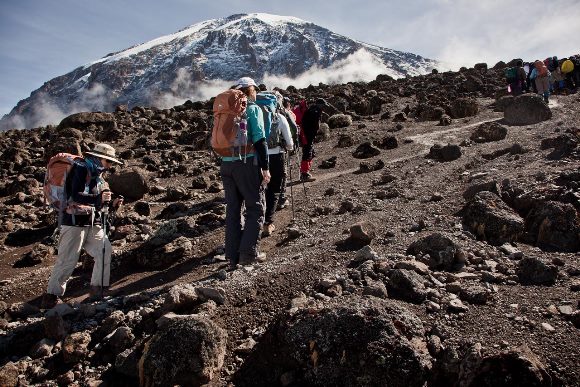
Although it is the quickest path to Mount Kilimanjaro, the steep slopes make it the most challenging. A trekker or climber should have previous trekking expertise because they must climb 900–1000 meters each day in 6–8 hours. In order to handle the challenges of high altitude and adverse weather, you must maintain physical and mental fitness. You could require a tree or its branches on your trip to maintain your balance on the slope. You could encounter the windiest and worst weather conditions in the high alpine zone.
Summiting Success rate of the Umbwe Route
The hardest trail on the mountain is the Umbwe route, which is also the steepest. The likelihood of success is usually lower on this difficult route. However, if you’re willing to push yourself, you’ll just fall in love with it. According to the report, a 6-day itinerary on the Umbwe route has a 70% success rate. However, compared to other routes, it also offers you the most beautiful view of the surrounding landscape.
Camping options in Umbwe route
There are three possibilities on a six-day Umbwe route tour at the Barranco camp. If you opt to head east after arriving at Barranco camp, you must pass through Karanga camp and Barafu camp in order to reach Uhuru peak. If you want to go west, you can use Lava Tower to get to Uhuru Peak. Going through Arrow Glacier Hut and to the summit of Uhuru Peak is the riskiest and most difficult alternative. Although the route offers an incredibly difficult journey, it can also strengthen the climber. The Umbwe trail offers a breathtaking perspective of the surrounding area.
The least number of people choose to use the Umbwe route for Mount Kilimanjaro climbing due to its difficulty, yet adventure seekers adore it. To reach Kilimanjaro’s Uhuru peak, you must put your body through better physical preparation. Before hiking Kilimanjaro’s toughest route, one needs to have a strong sense of determination and an optimistic outlook. Whatever the situation, don’t forget to take in the beautiful surroundings.
What is the scenery like on the Umbwe Route?
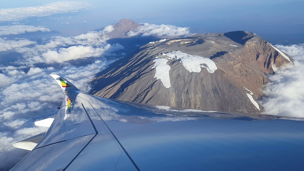
Before continuing on the steep Western Breach and Arrow’s Glacier path and climbing to the Reusch Crater (5,800 meters), where trekkers spend the night close to one of Kilimanjaro’s final remaining glaciers, Furtwangler Glacier, the first two days of the Umbwe Route trek pass through tree plantations and then beautiful and rich rain forest.
A one-hour optional hike to Reusch Crater is available from Crater Camp, or you may just wander around the region near Furtwangler Glacier. It’s a beautiful sight to see Reusch Crater. The ash pit is 1,300 feet (400 m) wide and 400 feet (120 m) deep, and it is almost perfectly circular. Tourists seldom ever see this.
When is the best time to trek the Umbwe Route?
The Umbwe Route is best hiked between July and September when the weather is most consistent and encountering rain is less likely. Nevertheless, given its proximity to the equator, the peak can be climbed at any time of the year. It is recommended to avoid the months of April and May because they are wet, How Difficult is it to Climb Umbwe Route to Mount Kilimanjaro?.
Short description of Umbwe route hiking
It takes 5 to 7 hours to travel from Umbwe gate, which is located at an altitude of 1614m, to Umbwe camp or cave camp (2940m). Reaching Barranco camp requires 4 to 5 hours of rainforest trekking (3976m). After that, it would take you 10 to 12 hours to get from Barranco Camp to Barafu Camp (4673m) via Karanga Camp. It takes 7 to 8 hours to get to Uhuru peak from Barafu camp (5895m). Mweka camp is 6 hours away from the Uhuru peak, while Mweka gate is 3 to 4 hours away.
6 DAY UMBWE ROUTE ITINERARY OVERVIEW
Starting from Umbwe Gate to the summit and finishing at Mweka Gate
MOUNT KILIMANJARO CLIMB – UMBWE ROUTE – 6 DAYS
DAY 1: FROM THE UMBWE GATE TO THE UMBWE CAVE CAMP
Before beginning our walk, we will register at the Umbwe Park Gate. We ascend the narrow, winding road that runs alongside the Umbwe River and through a jungle. At a height of roughly 2,900 meters, Umbwe Cave Camp serves as the campsite for the first night.
- Elevation (m): 1600m to 2900m
- Distance covered (km): 11km
- Trekking Time (hours): 6 hours
- Habitat: Montane Forest
DAY 2: FROM UMBWE TO BARRANCO CAMP
As soon as we leave camp, the woodland comes to an end. As the afternoon mists drift up the Great Barranco, we can see the sheer wall of the Western Breach appear and disappear. We’ll spend the night at the Barranco camp.
- Elevation (m): 2940m to 3970m
- Distance covered (km): 6km
- Hiking Time (hrs.): 4-5 hours
- Habitat: Montane Forest
DAY 3: FROM BARRANCO TO KARANGA CAMP
Today begins with a quick but enjoyable scramble to the Great Barranco Wall’s summit. To reach the Karanga Valley (3930m), which is located beneath the icefalls of the Heim, Kersten, and Decken Glaciers, we then travel through scree. We’ll spend the night at the campsite at Karanga, How Difficult is it to Climb Umbwe Route to Mount Kilimanjaro?.
- Elevation (m): 3950m to 3930m
- Hiking Time: 4 hours,
- Habitat: Alpine Desert
DAY 4: KARANGA CAMP TO BARAFU CAMP
In order to reach the intersection with the Mweka descending trail, we leave the Karanga campsite behind. From here, we proceed upward to the Barafu Hut. You have now completed the Southern Circuit, which gives numerous perspectives of the summit. We may rest, eat dinner, and get ready for the summit day in camp. From here, it is possible to see Mawenzi and Kibo‘s two peaks in full view.
- Elevation (m): 3930m to 4600m
- Hiking Distance: 6km
- Hiking Time: 3 hours
- Habitat: Alpine Desert
DAY 5: BARAFU CAMP TO SUMMIT TO MWEKA HUT
At 23:30, some fast tea and cookies will wake you up. Between the Rebman and Ratzel glaciers is where we begin our ascent to the top. As we approach Stella Point on the crater rim, we will move northwest and climb through steep scree. The hardest portion of the walk, both psychologically and physically, is this. We will take a little break at Stella Point (5732m) and be rewarded with the most spectacular sunrise you are ever likely to see. We will have reached the highest point on Mount Kilimanjaro and the continent of Africa at Uhuru Peak (5895m). At these altitudes, it can get fairly chilly at night, but by the end of the trekking day, it will be quite comfortable, How Difficult is it to Climb Umbwe Route to Mount Kilimanjaro?.
We stop at Barafu for lunch before descending to the Mweka Hut camp site from the summit. In order to navigate the loose gravel leading to Mweka Camp, trekking poles will be required. We will have our final meal on the mountain later in the evening before a well-deserved rest.
- Elevation (m): 4600m to 5895m (with a descent to 3100m).
- Distance covered: 7 kilometers ascent/23 kilometers descent
- Time required: 6-8 hours to ascend, 7-8 hours to descend
- Habitats: Stone scree and an ice-capped summit
DAY 6: FROM MWEKA CAMP TO THE HOTEL
After breakfast, we depart and descend to the Mweka Park Gate, where you will pick up your summit certificates for appreciation and congratulation for reaching the summit. It could be muddy and damp at lower altitudes. Trekking poles and gaiters will be useful. This will be the end of your 6 days Mount Kilimanjaro hiking through Umbwe route.
- Elevation (m): 3100m to 1800m
- Hiking distance: 8 km
- Hiking time: 3–4 hours
- Habitat: montane forest